
Survey-Grade Golf Course Mapping
That Pays for Itself
Stop Guessing. Start Knowing Exactly What's Underground.
Chosen by Leading Courses Worldwide
From championship venues to hidden gems, we help the best stay at their best.


Featured Project Spotlights
 PROJECT
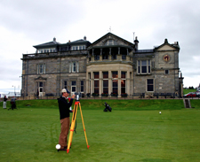
St. Andrews Links Trust
3D Modeling, LIDAR, Yardage Services
GeoGolf was selected to deliver 3D Modeling, LIDAR Scanning, Yardage Services, Planimetric Mapping, and Aerial Photography for St. Andrews Links Trust.
View Details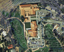 PROJECT
Monterey Peninsula Country Club
Mapping & Master Plan Services
GeoGolf provided full property aerials, 3D terrain topography, GIS, and planimetric mapping for Shore and Dunes Courses.
View Details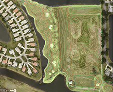 PROJECT
Gateway & Olde Hickory Golf Clubs
3D Terrain Modeling & Master Planning
GeoGolf supplied Aerial Photography, 3D Terrain Modeling, GIS, Signage, Yardages, and Master Planning Services across Florida's Gulf Coast.
View DetailsMade for the People Who Shape the Game
Precision mapping and design tools that turn your vision into reality - from design to daily operations.
Superintendents
Products designed to streamline daily operations, reduce maintenance costs, and save valuable time.
- Irrigation / Drainage As-Builts
- 3D Terrain Modeling
- Central Control Programming
- Maintenance Packages
Golf Architects & Builders
Tools that make course design and construction faster, more accurate, and easier to manage.
- GIS Services
- 2D Topographic Mapping
- Master Plan Map
- Sections 1–6 XRef
General Managers & Golf Professionals
Visual and promotional resources that elevate your course, enhance player experience, and improve course communication.
- On-Course Signage
- Yardage Books
- 3D Flyovers
- Scorecards
Proven Outcomes Across Diverse Courses
Visit our Clients Page to see how we've helped courses save time, cut costs, and elevate performance.
Explore GeoGolf Clients